
Iceland F-roads
F26 Sprengisandsleið (Sprengisandur)
Closed Road notes by Nimrod Ron · Iceland Lead & Content Curator· Updated
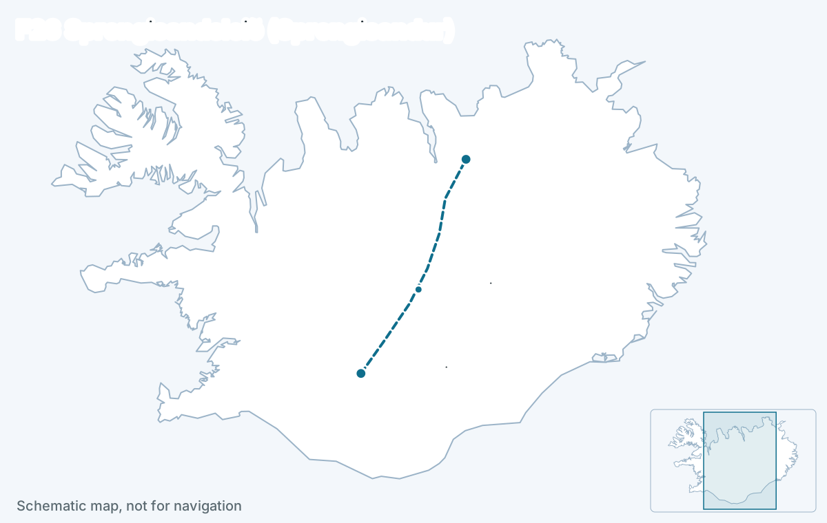
F26 Sprengisandsleið crosses the whole interior, about 200 km of black gravel desert between the Hrauneyjar area in the south and Bárðardalur near Goðafoss in the north, with no fuel, no shelter beyond the Nýidalur hut, and rivers that are not bridged. It opens late, in late June or early July, needs a high-clearance 4x4 and a second vehicle is advisable; it is a drive for experienced highland travelers, not a shortcut.
Key facts
- Connects
- Hrauneyjar (south, via Route 26) to Bárðardalur and Route 1 near Goðafoss (north)
- Length
- 200 km, about 6 to 8 hours without stops in good conditions
- Opens
- late June to early July
- Closes
- mid-September to early October
- Rivers
- Yes. Water tier 3: medium to large water crossings
- Car
- Large 4x4 with 30 cm or more of clearance and river experience
- Region
- Central Highlands (north–south crossing)
Status today
Closed
- Aldeyjarfoss – Mýri í BárðardalClosed
- Skagafjarðarleið – AldeyjarfossClosed
- VeiðivatnaskáliClosed
- Nýidalur – SkagafjarðarleiðClosed
- Vatnsfellsvirkjun – VersalirClosed
- Versalir – NýidalurClosed
- Nýidalur – SkagafjarðarleiðClosed
- Skagafjarðarleið – AldeyjarfossClosed
Source: umferdin.is (Icelandic Road and Coastal Administration), as of 29 Oct 2026, 09:51. Re-check road.is on the morning you drive.
The facts
| Fact | Value |
|---|---|
| Connects | Hrauneyjar (south, via Route 26) to Bárðardalur and Route 1 near Goðafoss (north) |
| Region | Central Highlands (north–south crossing) |
| Length of the F-road section | about 200 km |
| Driving time | 6 to 8 hours without stops |
| Status now | Closed |
| Typical opening | late June to early July |
| Typical closing | mid-September to early October |
| Difficulty | difficult |
| 4x4 required | Yes, by law |
| River crossings | Yes · water tier 3 |
| Car that fits | A high-clearance 4x4 — Toyota Land Cruiser, Land Rover Defender, or Toyota Hilux. |
Reaches: Þórisvatn and the Hrauneyjar lakes · Nýidalur hut · Views of Hofsjökull, Tungnafellsjökull and Vatnajökull · Aldeyjarfoss at the northern end
The road
Sprengisandur is the emptiest road in Iceland: a track across the sand and lava plateau between the Hofsjökull and Vatnajökull ice caps, at 700 to 800 m, with the only hut at Nýidalur halfway. It is rougher than Kjölur, with rocky sections, washboard and soft sand after dry spells, and it is fully exposed to weather that can turn a summer day into sleet.
The northern end drops into Bárðardalur past Aldeyjarfoss, one of the finest basalt waterfalls in the country and a reason to drive at least the last stretch from the north.
River crossings and the car
Several fords, with the Hagakvísl the one that changes most: shallow in the morning, dangerous after a warm afternoon or rain. F26 sits in the third water tier, which means a high-clearance 4x4 (Land Cruiser, Hilux, Defender class) rather than a compact one, and never a camper. Water damage is excluded from every rental insurance.
Water tier 3: Medium to large water crossings. A high-clearance 4x4 — Toyota Land Cruiser, Land Rover Defender, or Toyota Hilux.
When it opens
Late June to early July most years, among the last of the major F-roads because its rivers run high with melt, and it closes from mid-September to early October. The road authority sometimes opens the southern part first. Recorded dates are below.
| Year | First day open | Last day open | Days open | Days sampled |
|---|---|---|---|---|
| 2026 | not yet | – | 0 | 11 |
Download the data (CSV) · free to reuse under CC BY 4.0 with a link back.
How itineraries use it
Rarely, and only in plans of two weeks or more with a capable car: as the crossing between the Landmannalaugar area and the north, replacing the East Fjords. Most travelers who want the interior take Kjölur instead and keep Sprengisandur for a second trip.
Itineraries that use F26
Editor-picked Highlands plans from real trips drive this road or reach the places on it. Duplicate one and make it yours.
See itineraries with F26Questions about F26
What car do I need for F26 Sprengisandur?
A high-clearance 4x4 such as a Land Cruiser, Hilux or Defender, with F-road cover in the contract. Compact 4x4s and campers are not suitable because of the fords, and no insurance covers water damage.
Is there fuel on Sprengisandur?
No. The last fuel in the south is a single seasonal pump at Hrauneyjar, so fill at Hella or Selfoss; in the north the first pumps are at Fosshóll near Goðafoss or in Akureyri. The crossing is about 250 km of gravel and sand, and headwinds and soft surfaces raise consumption, so start with a full tank and a margin.
How long does the F26 crossing take?
Six to eight hours of driving for about 200 km in good conditions, more after rain. Start early, carry food and warm clothes, and check road.is and the weather the same morning.
When does F26 open?
Late June to early July in most years, and it closes between mid-September and early October. The live status above and the recorded dates by year show how the season has run.
Read next
Deeper reading on iceland-trip.com
Our sister site covers every place in depth: access, parking, seasons, what to expect. Written by the same team.
- Renting a car and driving in IcelandWhich car to rent, the insurance that matters, gravel and F-road rules, fuel, speed limits and the mistakes that cost visitors money.iceland-trip.com
- The HighlandsLandmannalaugar, Þórsmörk, Askja and the F-roads that reach them.iceland-trip.com
 Goðafoss Waterfall in Iceland: Complete Visitor GuidePlan your Goðafoss visit in North Iceland with practical advice on Ring Road access, parking, both viewpoints, winter safety, timing, nearby stops and stays.iceland-trip.com · North Iceland